Embedded Planning Guide to Uptown Whittier — A Photo Essay
Understand the city with your feet on the street.
As part of my Jobs For Justice talk “Why Be An Urban Planner?”, I led an Embedded Planning walking tour of Uptown Whittier with students from the Whittier College Sustainability Club. We examined the city’s historic district in a 2-hour trek from the lens of street-level planning. Our discussion of the built environment ranged from historic preservation and Hostile Architecture to park equity and Pandemic Urbanism. The images that follow show only a glimpse of the afternoon with our feet on the street.

Philadelphia Street and Painter Avenue
Image 1: Flyer for the walk. We began outside Mendenhall at Whittier College. This was an immersive “Part Two” of my Jobs For Justice talk at Hartley House. I illustrated Embedded Planning praxis at both events.

Painter Avenue and Mar Vista Street
Image 2: Outside the LA County Superior Court Whittier Courthouse, we examined a bus bench outfitted with conspicuous crossbars. These could be understood as handrails, but they have a more nefarious purpose: they prevent sleeping. It’s a common example of Defensive Design, also known as Hostile Architecture. I defined Hostile Architecture as elements of the built environment that prevent normal human activities — sitting, sleeping, playing — and target vulnerable populations. Hostile Architecture creates inequitable public space. I explained Mike Davis’s trailblazing critique in the Fortress LA chapter in City of Quartz. As we lost Mike last year, I encouraged the students to read his work so Mike can live on in us.


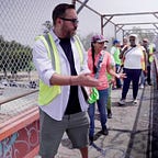
Mar Vista Street between Painter and Washington Avenues
Images 3–4: Here and throughout our walk, I explained the importance of planners putting their feet on the street. We cannot plan from our desks. We cannot plan with communities that we don’t know, communities we don’t go to. We cannot plan with communities that don’t know us. Good planning requires community trust — and trust is earned locally, I said. We have to be present.


Whittier Public Library
Images 5–6: We discussed the importance of public libraries. I created Embedded Planning praxis in the South Central LA community of Florence-Firestone, where I saw firsthand how libraries served as de facto community centers. Libraries are all-ages spaces of education, togetherness, and growth. Everyone is invited. Library staff double as community organizers. Planners can learn from public libraries. So important was this realization that I wrote a chapter on it in the first-ever Florence-Firestone community history book.

7600 block of Greenleaf Avenue
Image 7: We examined the different building arrangements reflecting how Whittier and the Los Angeles region evolved from pedestrian to car orientation. These parcels tell a story. The varying front-facing shops and parking lots suggest who was/is prioritized. Pedestrianism gives way to car culture. I remarked that this block encapsulates LA area planning.

Corner of Greenleaf Avenue and Mar Vista Street
Image 8: The LA region is notorious for erasure. This predilection has contributed to LA’s “place without a past” aspersions. But every community holds history, and Uptown Whittier is abundant. The beautiful old building at this corner underscores the importance of historic preservation. We observed how the architectural details, ornate brickwork, and arched windows signal a bygone era of design. I used this example to explain the epic Jane Jacobs vs Robert Moses battle in New York, a still-evolving chapter in planning history. With historic preservation codified into municipal law (along with earthquake retrofitting — and I pointed out all the exterior bolts!), artifacts like these are preserved for future generations to interpret.

7300 block on Greenleaf Avenue
Image 9: The historic Whittier train station wasn’t always here. Originally built in 1892 as the Southern Pacific Railroad Depot, the building’s original site was about a mile away on Bailey Street. Back then a fast growing city, Whittier proved a demand for rail expansion. But as local rail gave way to the car, so did rail architecture. The city acquired the structure to prevent demolition and moved it here in 2000. I described this site as further evidence of historic preservation for public good. We discussed how the building itself embodies Whittier’s social history. Cities can and should intervene to prevent place erasure. Move the building if you must.

7000 block of Greenleaf Avenue
Image 10: A vacant lot disrupts the storefronts near the center of Uptown Whittier. Buildings flanking the empty space reveal traces of what was there: a lone red brick wall clings to one building exterior, leftovers of beams protrude, the ghost of a structural grid is visible. These are remnants of community destruction after the 1987 Whittier Narrows earthquake. I shared memories of waking up terrified experiencing this violent temblor from my home nearby in Montebello. Eight people died. Multiple reports highlight extensive damage to unreinforced masonry buildings. In the aftermath, building codes were strengthened statewide. We discussed community memory and social history captured in the built environment. It’s there. Put your feet on the street and look.

Hartley House at Whittier College
Image 11: Flyer for my “Part One” talk that inspired the Uptown Whittier walk.

Hartley House at Whittier College
Image 12: I appreciated the speaking invitation from Dr. Rebecca Overmyer-Velázquez. This marked our third annual collaboration at Whittier College on careers in planning. This is what partnerships look like. I say we keep this talk going! Where are we doing “Why Be An Urban Planner?” next?
Images 1–10 by the Whittier College Sustainability Club. Image 11 by the Hartley House Jobs For Justice series at Whittier College. Image 12 by the author.